.png)

Terrain and environment digital twins built on measurable reality
We produce spatially reliable terrain and environment models for real time engines, simulation workflows and technical analysis. From large scale landscapes to high detail sites and built structures, including cultural heritage.
These terrain models form the spatial foundation for multiple downstream workflows including simulation platforms, infrastructure analysis, immersive systems and visual production environments.

Terrain refers to large scale landforms and ground surfaces captured with metric coherence.
Environment refers to the full scene context, including structures, geology, vegetation corridors and built heritage, captured and delivered as a single spatially consistent asset.
These assets are typically used for:
• Terrain context for real time worlds and level design
• Spatially consistent sets for virtual production and VFX environment work
• Technical visualization, measurement and change tracking
• Simulation scenarios where scale and geometry must be dependable
• Documentation and preservation of complex sites, including cultural heritage contexts
.png)
Technical case study
This case study presents a high-resolution Digital Terrain Model (DTM) of a sector of the Mora mountain range, generated from UAV-based aerial photogrammetry.
The dataset includes terrain-only geometry, slope analysis, Hillshade visualization, and a qualitative geomorphological interpretation, supporting terrain analysis, heritage assessment, and simulation-oriented workflows where geometric reliability is critical.
Download full technical dossier (PDF)
Environment and cultural heritage contexts
We capture and deliver heritage sites as environment assets that preserve spatial reliability. The goal is not only visual representation, but a model that remains usable across production and analysis contexts, with consistent scale and geometry.

Acquisition designed for metric coherence
We plan capture to support scale fidelity and repeatable results. Depending on the site, we combine aerial acquisition, ground coverage and control targets to reduce drift and preserve consistent geometry across the full environment.

Deliverables
Typical outputs include:
• High fidelity textured meshes and simplified game ready variants
• Terrain surfaces, orthomosaics, or height based representations when required
• Engine ready packages for Unreal workflows, with scale consistency
• Reference renders and viewpoints for review and alignment

Featured projects
1. Cliff environment scan, large scale rock face
This project captures a large scale cliff and rock face as a spatially accurate digital twin, preserving fine geological detail across complex vertical surfaces. The resulting model is suitable for visual effects, environmental reconstruction, and technical analysis where scale, geometry, and surface continuity are critical.

2. Terrain block scan – Peñas Negras hill, Mora (Toledo)
This project documents a complex rocky hilltop environment using aerial photogrammetry, producing a metrically accurate terrain digital twin with orthophoto and elevation-derived technical views. The resulting dataset supports spatial analysis, environmental documentation, and reuse in real time, visualization, and planning workflows where terrain fidelity is critical.
The nodel extent reflects effective acquisition boundaries under real-world operating conditions.

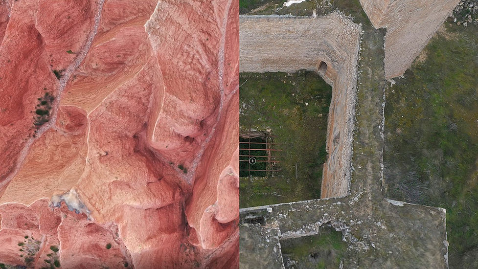
3. High fidelity digital twin of a fortified concrete structure
Spatially accurate digital reconstruction of a WWII-era blockhouse, captured and processed to preserve internal geometry, structural thickness and room connectivity. The model is suitable for documentation, technical analysis, simulation contexts and long-term digital preservation of built heritage assets.
.png)
4. Terrain Digital Twin – Rocky Hill and Access Corridor
This project is a high-resolution terrain digital twin created from aerial photogrammetry, designed to preserve topographic accuracy and measurable scale across the full landscape. The dataset supports technical visualization, analysis, and reuse in real-time and simulation workflows, including contour extraction and terrain-based studies.


5. Large scale terrain mapping and geospatial analysis
This project involved the acquisition and reconstruction of a continuous terrain digital twin covering approximately 192 hectares in Spain, captured through systematic aerial photogrammetry. The resulting dataset supports GIS workflows, including topographic analysis, surface continuity assessment, and integration with georeferenced vector and raster layers for planning, environmental analysis, and large scale spatial studies.
